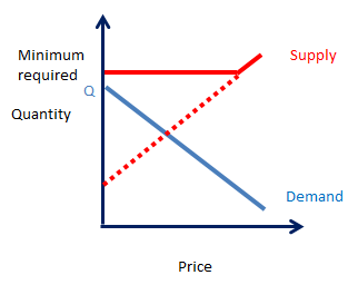
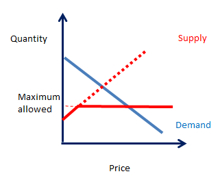
The idea of making public transit free of charge sometimes floats around on urbanist sites, as an ideal people dream of or as something they outright fight for. The reasoning is quite simple: if we want to incite people to take transit, then we need to make it as attractive as possible, including making it cheaper than using a car. After all, on this graph:
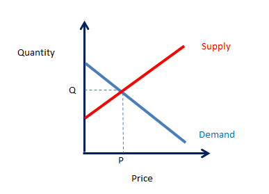 |
| Supply and demand graph |
Demand is highest when the price is zero, so if we want to maximize transit use, we should make it as cheap as possible, meaning, free.
Proponents also point out that most transit companies in North America are already mostly subsidized, with farebox revenues often making up only 20 to 30% of the company's spending, meaning that most of the revenues come from public money anyway, why not increase subsidies a bit and just make it free? You wouldn't only make transit more attractive, but you'd also speed up the process of boarding vehicles as people wouldn't have to stop and pay, they'd just get on as fast as they can.
There are a few cities in the world that have done so, but most of them are quite small. The biggest one to have done so is Tallin in Estonia, a city of around half a million people. However, transit is free only for residents and the suburban and commuter rail are not free, only slow local transit is.
So, is it all good then? I'm sorry, but I will dissent here, for a few reasons.
The big advantage of living in cities is less spending on transport, even as the price of housing increases. So when you subsidize transport, any transport, you eliminate the price advantage of city living, at least partially. Now, transit, especially bus transit, is much slower than cars, so transit "sprawl" is not as bad as car sprawl, and the developments built around transit are also not as bad, but it's still an incentive to live farther from central areas. An incentive paid for by the people living in urban areas, in effect a wealth transfer from the city to the suburb.
In fact, subsidies and taxes are sometimes necessary to incorporate externalities into the cost of goods and services. For those not in the know, "externalities" are costs imposed by transactions between two parties on third parties that weren't involved in them. The easiest example is pollution, which affects everyone in the area whether they are responsible for generating it or not.
Still, there is also a principle here that we call in French: "l'utilisateur-payeur", the "user-payer". It's a principle put forward by ecologists but which makes a lot of sense, the idea is that the one who USES a limited resources should PAY for it directly, in proportion to how much of it he uses. The idea is that if people pay the full cost of what their decision to consume a limited resource costs society, then we discourage waste of that resources and are able to incite people to adopt more responsible, miserly ways.
For instance, take electricity. In many if not most places, it's a public good. Yet we do not simply charge people say 2 000$ for unlimited electricity use over the year. In fact, proposing something like that would draw only mockery. Why should people who are careful of their energy consumption pay just as much as the people who leave their Christmas decorations on until May and who keep their lights on in their house all year long? We know that this is insane. Yet subsidizing transport, including making transit free to use, is doing just that.
Reducing, even eliminating, marginal costs, means that we encourage people to abuse the resources at their disposition, resources that we all share together. For instance, let's say you have a grocery at 5-minute walking distance and you want to buy a bag of apples for 4$, but another grocery farther, at, say, a distance of 5 minutes in bus, is selling apples for 3$. If the transit ticket costs 2$, then there's no point really to going to the farther grocery, it's cheaper to buy apples at your local grocery. If the transit trip is free though, then you're better off going to the farther grocery.
Free transit in fact has been theorized at mainly cannibalizing walking and biking trips rather than car trips. Which is inefficient on every level, there is no mode of transport that is more efficient than walking or biking, so if you get people who would have walked to take the bus instead, you are being counter-productive.
I hear some say: "But buses would be running anyway, we're just maximizing their use". That is not correct. As ridership increases, the number of buses needed also increases. Sure, if the line is really under-used, an increase of ridership can be simply absorbed by an higher capacity utilization, but that's not true on well-used lines, or during peak periods where buses are frequently at or near capacity.
The same thing is true about subsidizing car trips, especially long-distance ones. You essentially reward people for driving longer distances and wasting fuel. Rewarding selfishness and punishing selflessness by making the selfless pay for the selfish is a terrible idea. Which is why I'm in favor of shifting road funding from yearly fees and taxes to revenue sources that make people pay for roads depending on how much they use them: highway tolls and gas taxes.
BTW, these two reasons are why I support distance-based fares on transit rather than flat fares and monthly passes.
On the other hand, when you have no revenue coming from riders at all, you don't have this virtuous cycle. Riders represent a cost but no revenue to the transit agency, when ridership increases, the transit agency must find a way to run more vehicles and increase the capacity of the network. Consequently, the agency will not see that it's in its interest to find ways to increase transit use. It will also make large investments in transit systems like BRTs, LRTs and subways much less likely to occur, as the higher ridership from them will add to the costs of running the system, which are added on top of the capital investment needed to make these investments.
The transit agency's willingness to invest will depend directly on the will of the local government funding it to spend money on it. The local government will vote a budget and give them a certain amount of money and tell them to maximize the use of that money. Now, good news, this way of doing things tends to be great at maximizing efficiency as the objective of the operator is to maximize services for a fixed amount of money. Bad news, it means that if the budget is spent, the operator will reduce service below what people require, leading to "congestion" of the transit system and very angry users.
Worse news, running a transit system is pretty expensive, and a well-used one that is subsidized at 100% would weigh very heavily on the local government's budget. Which means that if there is a recession or a lack of money because of falling tax revenues or the like, it will be very tempting to cut the transit subsidies, and maybe even hard not to. So services on which people rely may well be cut below the minimum capacity to satisfy current demand.
This actually occurs quite often in American transit agencies which have low farebox recovery ratios and depend mainly on subsidies from the city to keep their buses running.
So in my opinion, an agency that is able to fund itself mostly through fares is more likely to results in wise investments on its transit system. Whereas a free transit system may well just grind to a halt investments in transit to increase service quality and capacity.
So, is it all good then? I'm sorry, but I will dissent here, for a few reasons.
Subsidizing transport is subsidizing sprawl
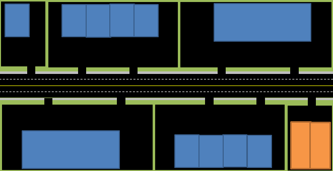
I think I don't need to demonstrate at length why subsidizing car transport is a great incitement to sprawl. Essentially, housing affordability is dependent not only on the price of housing, but also on transport costs. So when you lower the price of transport, especially cars, which are very fast, you essentially make car-centric suburbs more affordable and cities less affordable.
 |
| Cost as share of median income, housing and transport, if both pay their way |
 |
| Cost as share of median income, housing, transport and taxes, if transport is 50% subsidized |
Subsidizing transport is economically inefficient, encouraging waste
I already said this, but it bears repeating: in a money-based economy, the price of goods and services is an information vehicle. A higher price tells consumers that the good in question takes more resources and is not as common as other competing goods, encouraging them to consider these alternative goods. When you subsidize transport, you hide the real cost of people's consuming decisions. Now, I'm not saying that subsidies are always wrong, sometimes hiding the cost is a good thing (especially for health care), and you can make certain arguments about why letting the market decide the prices is suboptimal in relation to social and political objectives.
In fact, subsidies and taxes are sometimes necessary to incorporate externalities into the cost of goods and services. For those not in the know, "externalities" are costs imposed by transactions between two parties on third parties that weren't involved in them. The easiest example is pollution, which affects everyone in the area whether they are responsible for generating it or not.
Still, there is also a principle here that we call in French: "l'utilisateur-payeur", the "user-payer". It's a principle put forward by ecologists but which makes a lot of sense, the idea is that the one who USES a limited resources should PAY for it directly, in proportion to how much of it he uses. The idea is that if people pay the full cost of what their decision to consume a limited resource costs society, then we discourage waste of that resources and are able to incite people to adopt more responsible, miserly ways.
For instance, take electricity. In many if not most places, it's a public good. Yet we do not simply charge people say 2 000$ for unlimited electricity use over the year. In fact, proposing something like that would draw only mockery. Why should people who are careful of their energy consumption pay just as much as the people who leave their Christmas decorations on until May and who keep their lights on in their house all year long? We know that this is insane. Yet subsidizing transport, including making transit free to use, is doing just that.
Reducing, even eliminating, marginal costs, means that we encourage people to abuse the resources at their disposition, resources that we all share together. For instance, let's say you have a grocery at 5-minute walking distance and you want to buy a bag of apples for 4$, but another grocery farther, at, say, a distance of 5 minutes in bus, is selling apples for 3$. If the transit ticket costs 2$, then there's no point really to going to the farther grocery, it's cheaper to buy apples at your local grocery. If the transit trip is free though, then you're better off going to the farther grocery.
Free transit in fact has been theorized at mainly cannibalizing walking and biking trips rather than car trips. Which is inefficient on every level, there is no mode of transport that is more efficient than walking or biking, so if you get people who would have walked to take the bus instead, you are being counter-productive.
I hear some say: "But buses would be running anyway, we're just maximizing their use". That is not correct. As ridership increases, the number of buses needed also increases. Sure, if the line is really under-used, an increase of ridership can be simply absorbed by an higher capacity utilization, but that's not true on well-used lines, or during peak periods where buses are frequently at or near capacity.
The same thing is true about subsidizing car trips, especially long-distance ones. You essentially reward people for driving longer distances and wasting fuel. Rewarding selfishness and punishing selflessness by making the selfless pay for the selfish is a terrible idea. Which is why I'm in favor of shifting road funding from yearly fees and taxes to revenue sources that make people pay for roads depending on how much they use them: highway tolls and gas taxes.
BTW, these two reasons are why I support distance-based fares on transit rather than flat fares and monthly passes.
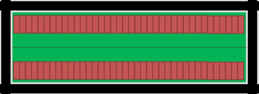
Free transit means increased ridership increases costs, but not revenues
This is more a political issue. When you have a self-funded transit system, or even one with a high farebox ratio, trying to increase ridership is a clear and evident objective of the transit operator. As ridership increases, revenues from fares increase. So the agency can justify investments by pointing out that much of the investment is recouped through more fare revenues. It's a virtuous cycle:
 |
| Virtuous cycle of self-funded transit systems |
The transit agency's willingness to invest will depend directly on the will of the local government funding it to spend money on it. The local government will vote a budget and give them a certain amount of money and tell them to maximize the use of that money. Now, good news, this way of doing things tends to be great at maximizing efficiency as the objective of the operator is to maximize services for a fixed amount of money. Bad news, it means that if the budget is spent, the operator will reduce service below what people require, leading to "congestion" of the transit system and very angry users.
Worse news, running a transit system is pretty expensive, and a well-used one that is subsidized at 100% would weigh very heavily on the local government's budget. Which means that if there is a recession or a lack of money because of falling tax revenues or the like, it will be very tempting to cut the transit subsidies, and maybe even hard not to. So services on which people rely may well be cut below the minimum capacity to satisfy current demand.
This actually occurs quite often in American transit agencies which have low farebox recovery ratios and depend mainly on subsidies from the city to keep their buses running.
So in my opinion, an agency that is able to fund itself mostly through fares is more likely to results in wise investments on its transit system. Whereas a free transit system may well just grind to a halt investments in transit to increase service quality and capacity.